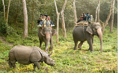
Home to an avid diversity of flora and fauna, which range from the lowlands of Terai to the Himalayan mountains. Each bio-zone host's multiple ecosystems, which are called home by thousands of species of birds, mammals, reptiles and amphibians. Nepal’s natural beauty has always been its pride and conserving it has always been a top priority. Thus under the National Parks and Wildlife Conservation Act, 2020 (1973AD), the government of Nepal created the guidelines to declare and maintain National Parks, Conservation Areas, and Hunting Reserves
Shivapuri Nagarjun National Park
Banke National Park
Shuklaphanta National Park
Parsa National Park
Today the protected areas of Nepal cover mainly forests and are located at various altitudes in the Terai, as well as in the foothills of the Himalayas and the mountains themselves. Nepal even though is small in terms of area size covering only 147,181 sq km. The altitudes range from 67 m to 8,848m. This extreme altitudinal gradient has resulted in 11 bio-climatic zones ranging from lower tropical below 500m to nival above 5,000m in the High Himalayas encompassing nine terrestrial ecoregions with 36 vegetation types. The government of Nepal under the National Park and Wildlife Conservation Act, 2020(1973AD) established a total of 12 National Parks, 1 Wildlife Reserves, 6 conservation Areas and 1 Hunting Reserve. In 2017, the Shuklpahanta and Parsa Wildlife Reserves were upgraded into National Parks.
In this series of articles, we explore the various National Parks, their level of accessibility and attractions.
Shivapuri Nagarjun National Park
Province: 03
Distance From Kathmandu: 32.5KM
Accessibility: One may choose to drive, ride or walk to the park due to its proximity to Kathmandu
Attraction: Wildlife Encounters, Cycling, Hiking, Sightseeing, Wildlife Encounters, Landscape Photography
Shivapuri Nagarjun National Park is the ninth national park in Nepal and was established in 2002. It is located in the country's mid-hills on the northern fringe of the Kathmandu Valley and named after Shivapuri Peak of 2,732 m (8,963 ft) altitude.
It covers an area of 159 km2 (61 sq mi) in the districts of Kathmandu, Nuwakot and Sindhupalchowk, adjoining 23 Village Development Committees. In the west, the protected area extends to the Dhading District. The area has always been an important water catchment area, supplying the Kathmandu Valley with several hundred thousands cubic litres of water daily. In 1976, the area was established as a protected watershed and wildlife reserve. In 2002, it was gazetted as Shivapuri National Park, initially covering 144 km2 (56 sq mi).It was extended by the Nagarjun Forest Reserve covering 15 km2 (5.8 sq mi) in 2009.
Banke National Park
Province: 05
Distance From Kathmandu: 472.6 KM
Accessibility: By Air, One can take direct flights to Nepalgunj and the park is an hour drive away. By Road, the park is 8 hours from the city of Mahendranagar and 7 Hours from Dhangadi, reaching the cities of Mahendranagar or Dhangadi is an additional 9-10 hours from Kathmandu.
Season: October- April
Attractions: Jungle Safari, Wildlife Encounters, Tiger Tracking, Landscape Photography, Cultural Experience, Fishing, Bird Watching, Cycling.
Banke National Park is located in the Mid-Western Region, Nepal and was established in 2010 as Nepal’s tenth national park after its recognition as a "Gift to the Earth". The protected area covers an area of 550 km2 (210 sq mi) with most parts falling on the Churia range. The park is surrounded by a buffer zone of 344 km2 (133 sq mi) in the districts of Banke, Salyan and Dang.
Together with the neighbouring Bardia National Park, the coherent protected area of 1,518 km2 (586 sq mi) represents the Tiger Conservation Unit (TCU) Bardia-Banke. The protected area holds tiger and four-horned antelope. In 2014, a ruddy mongoose was recorded for the first time in the protected area.
Shuklaphanta National Park
Province: 7
Distance From Kathmandu: 700 KM
Accessibility: By Air, one can take direct flights to Dhangadi Airport and the park centre is a 2-hour drive at a distance of 66 Km.
Season: Mid September- Mid December or February- May
Shuklaphanta National Park is a protected area in the Terai of the Far-Western Region, Nepal, covering 305 km2 (118 sq mi) of open grassland, forests, riverbeds and tropical wetlands at an altitude of 174 to 1,386 m (571 to 4,547 ft). It was gazetted in 1976 as Royal Shuklaphanta Wildlife Reserve. A small part of the reserve extends north of the East-West Highway to create a corridor for seasonal migration of wildlife into the Sivalik Hills. The Syali River forms the eastern boundary southward to the international border with India, which demarcates the reserve’s southern and western boundary.
The Indian Tiger Reserve Kishanpur Wildlife Sanctuary is contiguous in the south; this coherent protected area of 439 km2 (169 sq mi) represents the Tiger Conservation Unit (TCU) Sukla Phanta-Kishanpur, which covers a 1.897 km2 (0.732 sq mi) block of alluvial grasslands and subtropical moist deciduous forests.
The protected area is part of the Terai-Duar savanna and grasslands ecoregion and is one of the best-conserved examples of floodplain grassland. It is included in the Terai Arc Landscape.
Parsa National Park
Province: 2
Distance From Kathmandu: 106 KM
Accessibility: By Air and road, one can drive or take a flight to Simra in Bara District from where the reserve headquarters is seven kilometres away.
Attractions: Jungle Safari, Wildlife Encounters, Jungle Hikes, Wildlife Photography, Cultural Experience
Parsa National Park is a protected area in the Inner Terai lowlands of south-central Nepal. It covers an area of 627.39 km2 (242.24 sq mi) in the Parsa, Makwanpur and Bara districts and ranges in altitude from 435 m (1,427 ft) to 950 m (3,120 ft) in the Siwalik Hills. It was established as a wildlife reserve in 1984. A buffer zone declared in 2005 comprises 285.3 km2 (110.2 sq mi). In 2015, the protected area has been extended by 128 km2 (49 sq mi). Since 2017, it has the status of a National Park.
In the north of the protected area, the Rapti River and Siwalik Hills form a natural boundary to human settlements. In the east, it extends up to the Hetauda – Birgunj highway. In the south, a forest road demarcates the boundary. Adjacent to the west is Chitawan National Park. Together with the Indian Tiger Reserve Valmiki National Park, the coherent protected area of 2,075 km2 (801 sq mi) represents the Tiger Conservation Unit (TCU) Chitwan-Parsa-Valmiki, which covers a 3,549 km2 (1,370 sq mi) block of alluvial grasslands and subtropical moist deciduous forests.