It is the Arniko Highway that most trekkers drive on to get to their respective take-off points for quite a few treks in regions north of the capital. It’s a good road, so that’s a good thing, because you reach your destination faster, saving you precious time. And so, that’s how you start your Kalinchowk trek, it’s a pleasant beginning. However, you might be less pleased to know that you’ll be trekking in an isolated area and hiking through some pretty dense forests on the way, one of which, especially, has seen its fair share of robberies. So, be warned!
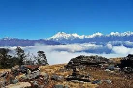
Anyway, you first drive to Charikot, which should take around five hours. This picturesque town is 133 km northeast of Kathmandu, atop a hill at 1,733 meters. The trek to Kalinchowk from here mean you will be climbing to a height of 3,782 meters, and so it is bound to challenge your mettle, both physical and mental. At the same time , it need not be said that the scenery you encounter will be really lovely, the route passing across terraced fields of millet and mustard, forests of sweet smelling pine trees, hemlock, and what not, and thick droves of gracefully swaying bamboo. Soon after you start hiking, you’ll get splendid views of the Tamakosi River way down below, to the south, while to the north are of course, the mighty Himalayan peaks, Gaurishanker (7,134 m) being, without a shred of doubt, the most prominent and impressive.
As you near Chothang village, which is also called “Hotel Danda”, you will observe chortens with Nepali inscriptions and stone memorials with Tibetan inscriptions all along the trail. Such memorials to the dead is a common tradition for the largely Sherpa, Magar, Lama, and Tamang villagers who live around here. Carry on hiking, and now you’ll notice that there’s a clear change in the geography, with the rhododendron and pine forests becoming denser as you climb, and at some point, you’ll find the tall trees almost completely blocking out the light. This is where many robberies apparently have occurred, so you’ll be walking a bit faster through this part of the woods, right?
All going well, and no Robin Hoods having made their presence felt, you emerge onto a lovely setting that’s pretty enchanting. It has as its centerpiece, a heart-shaped, moss-covered pool of water, that’s known as Simpani. You can rest easier now, and take your time enjoying the beautiful scenery, since your next stop will be at a place only a half hour later; it’s called Deurali (2,350 m), and it has some very welcome teashops. And, hot tea is what’s most welcome, what with the chilly weather up here. A fork up ahead has tracks going down to some villages. Chhyamamwati and Makaibari have Tamang, Magar, and Sherpa inhabitants, while Shuspa village has an ethnic group called Thami.